![](/images/other/stat-length.png)
![Tocht Te voet Bad Doberan - Kühlungsborn-Heiligendamm-Bad Doberan - Photo](https://media.geolcdn.com/t/1900/400/ext.pjpeg?maxdim=2&url=https%3A%2F%2Fmedia.geolcdn.com%2Ff%2F752de6c8-ac47-4611-896f-949dd63cda64.jpeg)
Kühlungsborn-Heiligendamm-Bad Doberan
SityTrail - itinéraires balisés pédestres
Tous les sentiers balisés d’Europe PRO
![Lengte](/images/other/stat-length.png)
Lengte
14 km
![Max. hoogte](https://static1.geolcdn.com/siteimages/upload/files/1508320355ic_sort_altitude_max_24dp.png)
Max. hoogte
26 m
![Positief hoogteverschil](https://static1.geolcdn.com/siteimages/upload/files/1508320355ic_sort_den_pos_24dp.png)
Positief hoogteverschil
75 m
![Km-Effort](/images/other/stat-length.png)
Km-Effort
15,1 km
![Min. hoogte](https://static1.geolcdn.com/siteimages/upload/files/1508320355ic_sort_altitude_min_24dp.png)
Min. hoogte
-4 m
![Negatief hoogteverschil](https://static1.geolcdn.com/siteimages/upload/files/1508320355ic_sort_den_neg_24dp.png)
Negatief hoogteverschil
91 m
![Boucle](https://static1.geolcdn.com/siteimages/upload/files/16400158638029165_repeat_loop_refresh_sync_direction_icon.png)
Boucle
Neen
Markering
Datum van aanmaak :
2022-02-11 13:09:44.18
Laatste wijziging :
2022-02-11 13:09:44.18
![Te voet](https://static1.geolcdn.com/sitytour/trail-icons/100.png)
3h25
Moeilijkheid : Gemakkelijk
![Scan deze QR-code om de tocht te openen in de SityTrail-applicatie](https://capi.geolives.com/qq0zvz2zws4bq2lad0pu/sitytour/trails/3089327/qr.png?size=200)
Gratisgps-wandelapplicatie
Over ons
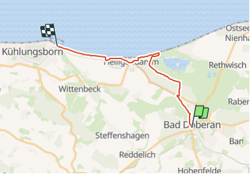
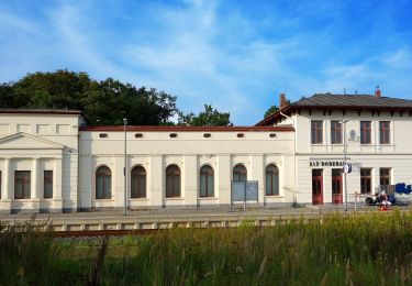
Tocht Te voet van 14 km beschikbaar op Mecklenburg-Voor-Pommeren, Landkreis Rostock, Bad Doberan. Deze tocht wordt voorgesteld door SityTrail - itinéraires balisés pédestres.
Beschrijving
Trail created by Stadt Bad Doberan.
Symbol: 3, mit gelbem horizontalem Strich auf weißem Grund
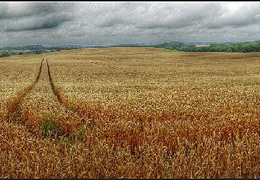
Plaatsbepaling
Land:
Germany
Regio :
Mecklenburg-Voor-Pommeren
Departement/Provincie :
Landkreis Rostock
Gemeente :
Bad Doberan
Locatie:
Unknown
Vertrek:(Dec)
Vertrek:(UTM)
689747 ; 5999010 (32U) N.
Opmerkingen
Wandeltochten in de omgeving
![Tocht Te voet Hohenfelde - Glashäger Quellental - Photo](https://media.geolcdn.com/t/375/260/ext.jpg?maxdim=2&url=https%3A%2F%2Fmedia.geolcdn.com%2Ff%2F03964c50-e1bb-4c50-98f0-ca4d4f683044.jpeg)
![Te voet Te voet](https://static1.geolcdn.com/sitytour/trail-icons/100.png)
Glashäger Quellental
Te voet
Gemakkelijk
Hohenfelde,
Mecklenburg-Voor-Pommeren,
Landkreis Rostock,
Germany
![](/images/other/stat-length.png)
3,1 km | 3,6 km-effort
49min
![](https://static1.geolcdn.com/siteimages/upload/files/16400158638029165_repeat_loop_refresh_sync_direction_icon.png)
Neen
![Tocht Te voet Reddelich - Rundweg über Reddelich - Photo](https://media.geolcdn.com/t/375/260/ext.jpg?maxdim=2&url=https%3A%2F%2Fmedia.geolcdn.com%2Ff%2F590a17b6-65da-4e0b-bf68-a58b6eeabf0e.jpeg)
![Te voet Te voet](https://static1.geolcdn.com/sitytour/trail-icons/100.png)
Rundweg über Reddelich
Te voet
Gemakkelijk
Reddelich,
Mecklenburg-Voor-Pommeren,
Landkreis Rostock,
Germany
![](/images/other/stat-length.png)
13,7 km | 15,8 km-effort
3h 35min
![](https://static1.geolcdn.com/siteimages/upload/files/16400158638029165_repeat_loop_refresh_sync_direction_icon.png)
Ja
![Tocht Te voet Bad Doberan - Doberaner Klostertour - Photo](https://media.geolcdn.com/t/375/260/ext.jpg?maxdim=2&url=https%3A%2F%2Fmedia.geolcdn.com%2Ff%2Fbe511db8-ceec-4703-9b74-5e49bfca8bbc.jpeg)
![Te voet Te voet](https://static1.geolcdn.com/sitytour/trail-icons/100.png)
Doberaner Klostertour
Te voet
Gemakkelijk
Bad Doberan,
Mecklenburg-Voor-Pommeren,
Landkreis Rostock,
Germany
![](/images/other/stat-length.png)
12,6 km | 14,6 km-effort
3h 18min
![](https://static1.geolcdn.com/siteimages/upload/files/16400158638029165_repeat_loop_refresh_sync_direction_icon.png)
Ja
![Tocht Te voet Bad Doberan - Hütter Wohld - Bad Doberan - Photo](https://media.geolcdn.com/t/375/260/ext.jpg?maxdim=2&url=https%3A%2F%2Fmedia.geolcdn.com%2Ff%2Fb51289b2-57f2-4601-adbf-880d148522cf.jpeg)
![Te voet Te voet](https://static1.geolcdn.com/sitytour/trail-icons/100.png)
Hütter Wohld - Bad Doberan
Te voet
Gemakkelijk
Bad Doberan,
Mecklenburg-Voor-Pommeren,
Landkreis Rostock,
Germany
![](/images/other/stat-length.png)
16,5 km | 19,2 km-effort
4h 21min
![](https://static1.geolcdn.com/siteimages/upload/files/16400158638029165_repeat_loop_refresh_sync_direction_icon.png)
Ja